|
|
|
|
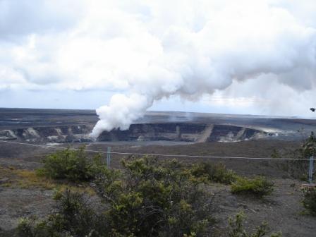
A Voggy Day in Kona 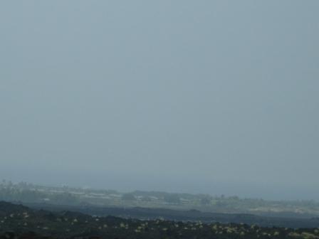 Kilauea volcano on the island of Hawaii is an active volcano releasing toxic gasses which affect the air quality across the entire state of Hawaii. Parts of Hawaii County have been declared a disaster area due to lost crops and grazing lands. Some people have had health effects, particularly those with breathing problems or asthma. People have different reactions to the vog. Some get sore throats and feel terrible and others barely notice. It is the same with the trees and plants. Some plants dry out and die while others seem to be fine with the acidity. Kilauea is on the southeast side of Mauna Loa with an elevation of 4,091 feet (1,247 meters). Within Kilauea's caldera, there is a smaler crater called Halema'uma'u which is where much of the gas, ash and occasional eruptions of lava are coming from. Additional vents are continuing to open up along the flanks of the Pu'u crater, which is located15 miles closer to Hilo. These vents are emitting lava which sometimes makes it all the way to the ocean at Kalapana or within Volcanoes National Park. The USGS has a live CAM of Kilauea's eruption activity. At night the crater sometimes glows and even emits bright red particles high into the sky.
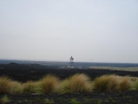
The Halema'uma'u crater is constantly spewing out volcanic emissions and ash. The crater is viewable from Volcanoes National Park lookout at the the Jagger Museum. NASA's Earth Observatory has been monitoring Kilauea output from space. The Ozone Monitoring Instrument (OMI) on NASA’s Aura satellite recorded the sulfur dioxide rising out of Kilauea. The gases build up on southwest side of Hawaii Island (that big red blob) and move northwest with the prevailing trade winds causing a lot of Vog (volcanic emissions) on the leeward side of Hawaii County. When the Kona coast heats up during the day, the Vog is often sucked in from the ocean and covers the town. The state of Hawaii Department of Health has map of the air quality from measuring stations on all the islands. At this point there seems no end to the continuous eruptions from the volcano. Information about the toxicity of SO2 is available here from the ATSDR (Agency for Toxic Substances & Disease Registry). Information about Hawaii's Current Air Quality Conditions from the EPA are here. Here is a view from Hwy 11 driving past the Kona airport. Here is a video of the drive by the Kona airport during a Voggy day. Normally you can see a crystal blue ocean beyond the black lava.
This is a video of the volcanic activity from the Volcanoes National Park:
Copyright 2012 |
| Back to Home |
| About Kona Area |
| Kona Beach Maps |
| Kona Parks |
| County Resources |
| Island Volcano Watch |
| Island Environ Monitor |
| Island Web CAMs |
| Kona Web Links |